")
")

The Dragon Country
Viet Nam is one of the most singular countries in Asia, both by its history, its unusual landscapes and by its numerous ethnicities. Located at the very crossroads of the South East Asia countries, connecting China to Indonesia, Vietnam spreads itself between the 8th and the 23rd North parallel on almost 1650km along the Gulf of Tonkin (the Ha Long Bay) and the China Sea. Its center is very narrow (50km up from Da Nang), it widens in the North (the mountains at the boarder of China and Laos) and in the South (plains of the Mekong and the boarder of Cambodia).
We can easily imagine the country in the shape of an ‘’S’’. Vietnamese people rather consider it as in the shape of a dragon (con tan; recurrent animal from the Vietnamese tales and folklore) or as two baskets of rice carried at the extremities by a bamboo stick (don ganh)…
The country can be divided in three areas:
The country is divided in 56 provinces and 6 main cities, spread in three big different geographic areas: the Bac Bo (North), the Trung Bo (Center) and the Nam Bo (South):
 Bac Bo : Hanoi and the Red River Delta, the Ha Long Bay and the Gulf of Tonkin, the mountains of the North and North-West, the mountain ethnicities, Ninh Binh and the terrestrial Ha Long Bay, Mai Chau, Dien Bien Phu, Sapa…
Trung Bo : Seaside beaches and highlands going from Kontum to Plei Ku, the imperial citadel of Hue, Hoi An, Da Nang…
Nam Bo : Beach resorts, Da Lat city, the Delta of Mekong, Phu Quoc island and the gulf of Thailand, Mui Ne, Nha Trang…
Vietnamese landscapes
Viet Nam has two third of its surface area covered by mountains and hills where the ethnic minorities live. Its highest point, mount Phan Si Phan near Sapa (in the North West), overlooks the Hoang Lien Son mountain ranges from an altitude of 3143m. Mount Ngoc Linh (2598m) in the Truong Son cordillera marks the border with Laos and overlooks the highlands of Trung Bo.
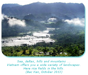
Vietnamese landscapes thus introduce numbers of small valleys and water streams crossing the territory. The alluvial plains are covered with rice fields and display scattered villages. Big cities gather together the main part of the population.
Karstic formations are typical in the Vietnamese landscape and can be seen across the country. These are hills or rocky peaks irregularly punctuating the scenery. Scientifically, this is in fact limestone massifs that have been eroded by water flows, where vegetation grows directly on rock.
You will also find granitic massifs along the shore, especially by the clouds pass (Hai Van), or even by some extinct volcanoes on the highlands and in the North of Ho Chi Minh City.
Fauna and flora
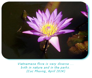
Viet Nam displays remarkable primary forests: temperate in the North, tropical in the South and on the highlands. There are even mangrove forests on the coastline and along water streams. Being integral part of the world’s natural heritage, these locations are threatened by deforestation. Clearing forests is something widely practiced nowadays in order to compensate a demographic pressure growing stronger and stronger, hence making the competition greater for landowners to build and cultivate… at the expense of the forest! Numerous natural reserves and thirteen national parks have thus been created in order to protect the environment and to sensitize the Vietnamese people. You will find there less visited itineraries than from the traditional ‘’must see’’ ones. Vietnamese fauna is unfortunately hardly visible, yet so rich, given the numerous dwellings and environments present. Nowadays, we can count up to 275 species of mammals, up to 800 species of birds, 180 species of reptiles, 80 amphibians, hundreds of fishes and thousands of invertebrates. Among them, maybe will you have the luck to see a leopard, a tiger, an elephant, a snub-nose monkey or even a flying squirrel!
Deltas, dwelling areas and attics of Viet Nam
The deltas of the Red River and of the Mekong are the most fertile areas of the country and gather the most of the ‘’Viet’’ population. The peculiar color of the water streams come from the alluvium they carry along their long and sinuous itinerary. Torrential rains during the monsoon are the source of massive swelling, floods and more often than not of population displacement. Alluvial valleys are large agricultural areas, especially in rice culture. They are the attics of Viet Nam, in the same manner as the French Beauce is for cereals. From the pricking out to the harvest the lands are covered in different shades of green, only interrupted by embankments giving access to the parcels and some surfaces destined to other agricultural ends: peanut, soy, corn or sugar cane farming.